Thursday, April 18, 2013 - Blog on a Log
Mantario Hiking Trail Maps now available at Wilderness Supply
If you're wondering where to buy a Mantario Hiking Trail map in Winnipeg, maps are now back in stock at both Winnipeg Wilderness Supply locations, 623 Ferry Road and 42 Speers Road. The $10.99 waterproof map is the go-to resource for any Mantario hiker, showing the topography of the 63-km trail plus all ten designated campsites with distances and estimated hiking times between.
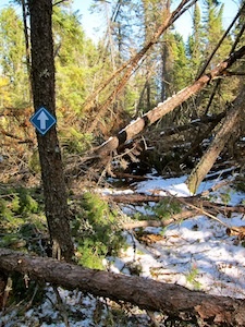
Hikers will have to use the maps for planning purposes for the time being, however, as a large wind and snowstorm late last year has left the trail nearly impassible. The photo below, taken by a Wilderness Supply staff member a few days after the storm, shows a sample of the damage to most of the southern half of the trail.

Manitoba Conservation has officially closed the trail, stating:
The Mantario Trail is closed due to severe snow damage that occurred October 4, 2012. The trail has trees blocking various portions of the trail, therefore making trail conditions unsafe for hiking.
The Mantario Hiking Trail is approximately 60kms long and is a difficult challenge to even the most experienced hiker. Access to the damaged area to clean-up will be very difficult and with winter weather fast approaching, clean-up efforts will have to be postponed until the Spring of 2013.
The Mantario Trail will be surveyed in the spring of 2013 to further assess damage. Clean-up efforts will be scheduled to start as soon as trail conditions are safe for staff to conduct the clean-up (Spring 2013).
Updates will be posted to the Manitoba Conservation website once cleanup has begun.
More information: Manitoba Parks - Hiking

